Continuing to increase in strength over very warm ocean waters, Hurricane Fiona is now a Category 4 hurricane with maximum sustained winds near 215 kilometres per hour as it moves due north of the Turks and Caicos Islands.
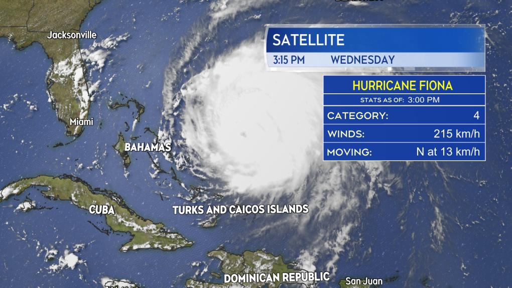 Hurricane Fiona is a Category 4 hurricane as it moves due north of the Turks and Caicos Islands.
TRACK
Little has changed in the overall forecast track of the storm Tuesday into Wednesday. Fiona is forecast to progress northward as a Category 4 hurricane passing to the west of Bermuda early Friday morning. It is expected to enter the Scotian Slope marine area of Atlantic Canada as major Category 3 hurricane late Friday night. Fiona is then forecast to approach eastern Nova Scotia as a Category 2 hurricane transitioning into a powerful post-tropical storm.
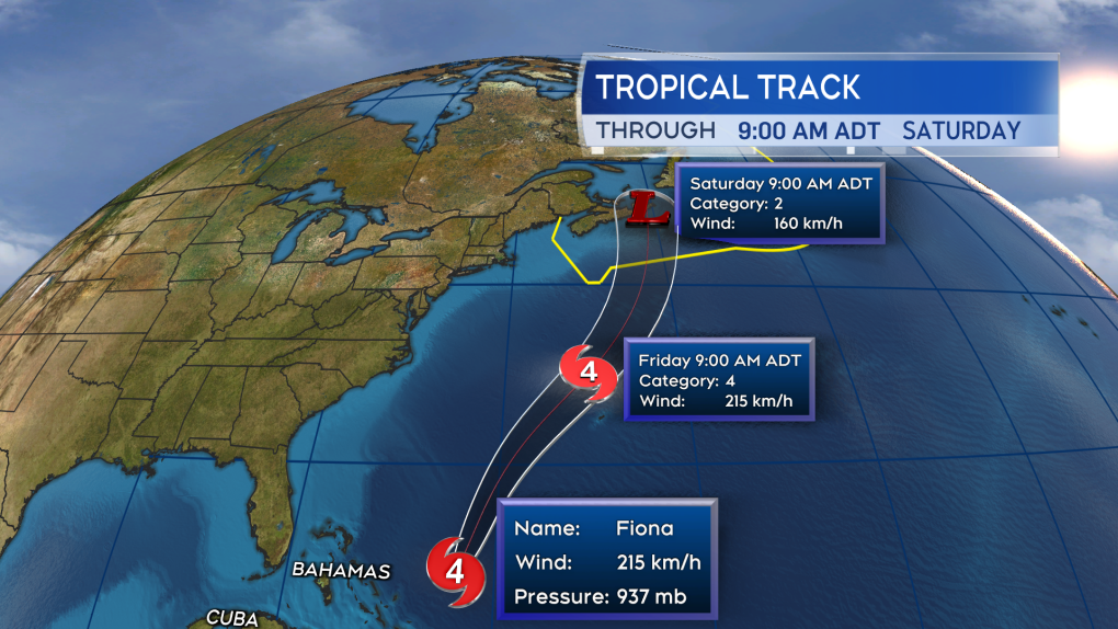 Fiona is forecast to continue as a major hurricane as it enters the southern most waters of the region.
LANDFALL
It looks increasingly likely that Fiona will make landfall somewhere in the area spanning Guysborough County to the eastern most point of Cape Breton County in Nova Scotia Saturday morning. There is still time to see change in that projection as the forecast cone -- the area the centre of the storm is likely to take a path through -- still reaches from eastern Halifax County into western Newfoundland.
Regardless of the landfall point, there are going to be broad impacts from wind, rain, and storm surge to the Maritimes. Weather conditions will deteriorate Friday night into Saturday.
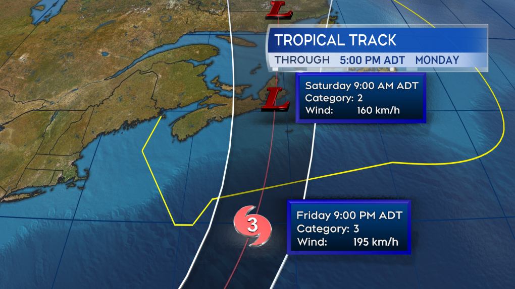 A landfall as a powerful post-tropical storm looks likely in eastern Nova Scotia on Saturday morning.
BROAD IMPACTS
As the storm turns post-tropical, it will be stretched and grow in size. This will also expand the area of rain and wind outwards from the centre of the storm.
With these storms, the heaviest rain often falls along and west of the track. This would give a risk of a large portion of Prince Edward Island, as well as the eastern half of Nova Scotia, seeing possible totals of 80 to 150+ millimetres, with the rain torrential at times. That will also give a risk of flooding, flash flooding, and washouts.
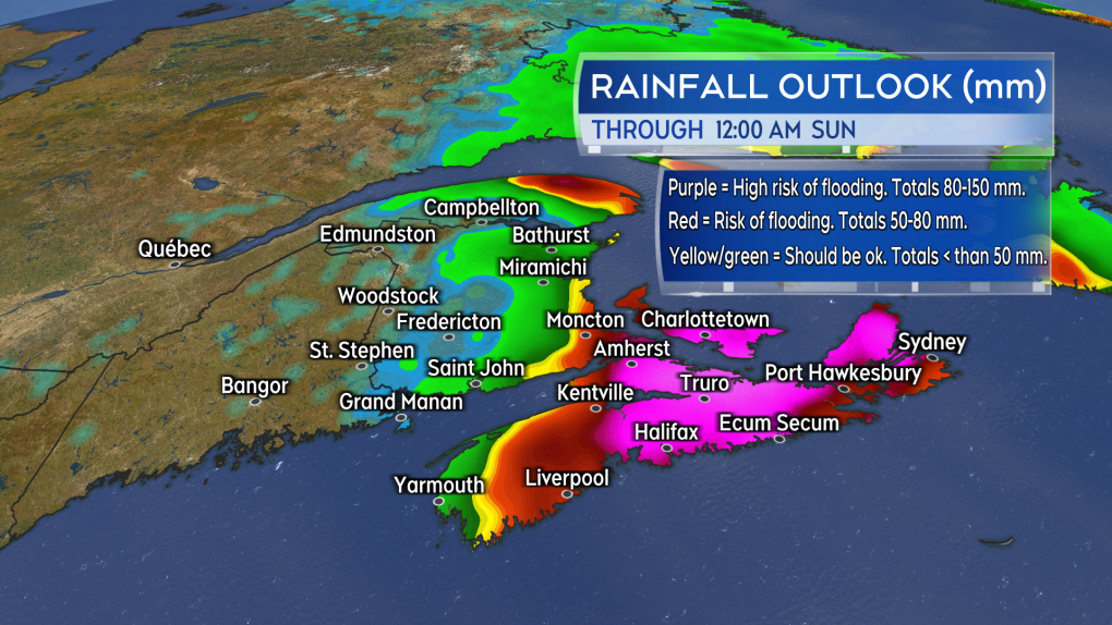 Torrential rain will bring a risk of flooding. The risk is highest for P.E.I. and central/eastern areas of Nova Scotia.
As with the rain, the wind field of the storm will expand to bring a widespread impact to the Maritimes. While the strongest of the winds are likely to be found at and just east of the passage of the centre of the storm, a large portion of the Maritimes is at risk of tropical storm force winds. A tropical storm force wind is defined as a one-minute sustained wind of 63 kilometres per hour, which would almost certainly give peak gusts reaching or exceeding 100 kilometres per hour. The probability of that type of wind occurring for a period of time Friday night into Saturday is now high for P.E.I. and the eastern half of Nova Scotia.
The strong winds will bring power outages and the risk of fallen branch and tree debris. There is still near full foliage on the trees and the presence of leaves can act to increase the force of the wind on them.
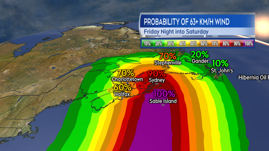 The highest probability of winds reaching at least tropical storm force strength continues to be eastern Nova Scotia and Prince Edward Island.
A higher than normal surf and crashing waves will be present for most of the coast Friday through Saturday. The risk of a storm surge will be higher on the eastern Atlantic coastline of Nova Scotia -- particularly Cape Breton -- as well as the North Shore of Nova Scotia and the northern coastlines of P.E.I. on Saturday.
PREPARATIONS
Most in Nova Scotia, Prince Edward Island, and eastern New Brunswick should be taking some preparation ahead of the storm. Anyone using a sump pump or generator should check to make sure those are in working order and that they have fuel. It is also important to make sure that battery operated devices are charged or that you have a means to charge them in the event of a power outage.
Other preparations may include:
- clearing property drainage of any late summer debris
- having food and medication that can last you during the storm and for a few days after
Consider postponing travel during the passage of the storm, which again is mainly Friday night through Saturday morning and afternoon.

Post a Comment