A coastal storm strengthening near Cape Cod, Mass., early Tuesday morning will move towards the southwest of Nova Scotia on Wednesday before moving east of the Maritimes Thursday.
Special weather statements are in effect for all three Maritime provinces cautioning that some snow totals could reach and exceed 10 cm. Snowfall warnings are in effect for parts of eastern New Brunswick calling for 15 to 20 cm of snow Tuesday through Wednesday.
Snowfall warnings for Cape Breton, Richmond, and Guysborough counties in eastern Nova Scotia call for totals of 15 to 25 cm Tuesday through Wednesday.
A les suêtes wind warning is out for northern Inverness County in Cape Breton. Such a warning is issued when there is a significant risk of damaging winds.
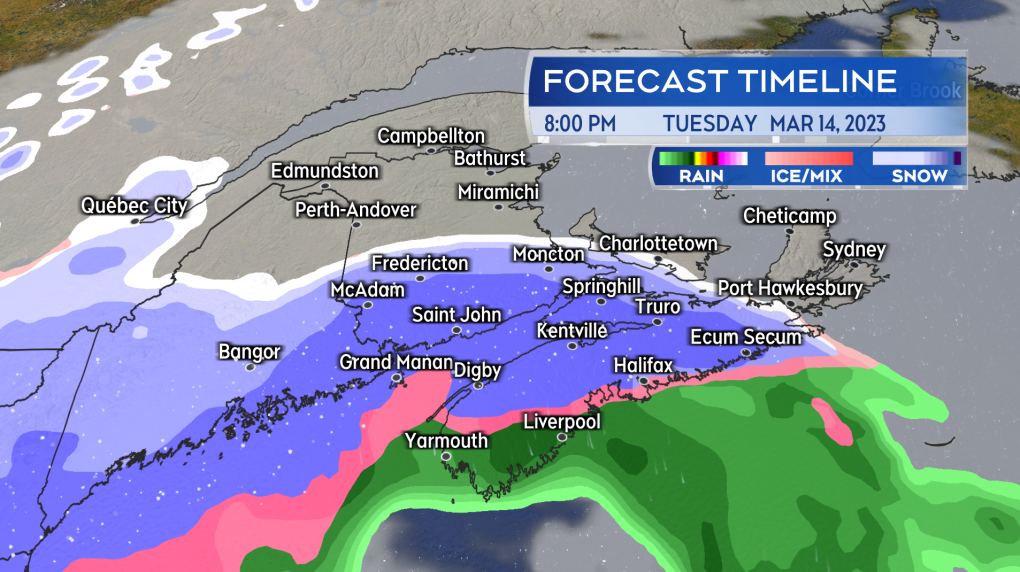
 Snow moves in west to east Tuesday afternoon through evening, with a turn to rain for much of mainland Nova Scotia.
TIMING
Due to the slow motion of the weather system, the region will be contending with weather impacts Tuesday afternoon through Wednesday night with possible lingering snow for eastern areas into Thursday morning.
Inclement weather expected includes areas of heavy snow turning to rain, high winds, and a rough and pounding surf. Snow will develop west-to-east across the Maritimes Tuesday afternoon through Tuesday evening.
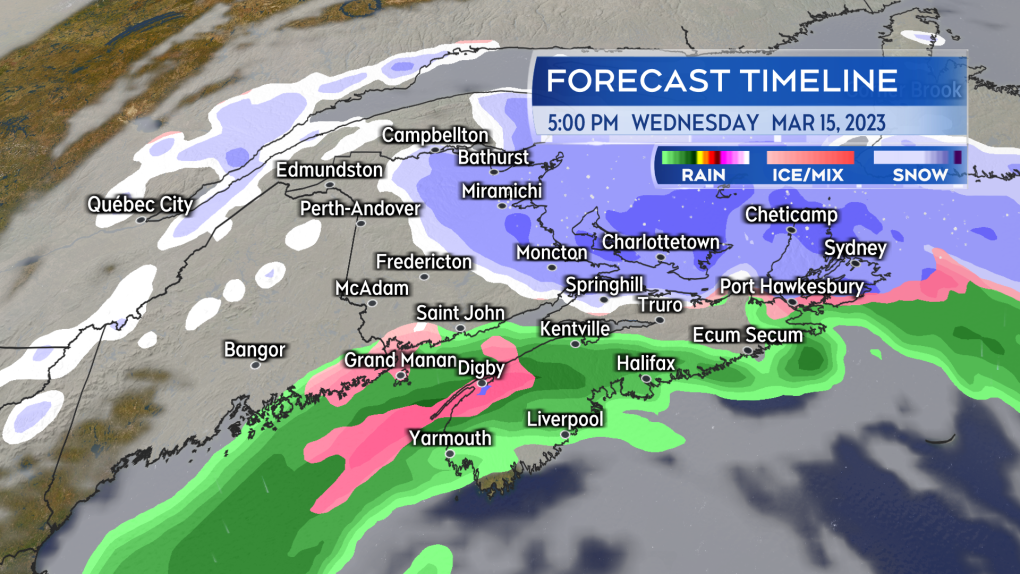
A change from snow to rain is expected for mainland Nova Scotia as well as along the Bay of Fundy coastline in New Brunswick. Some rain may mix with the snow on Prince Edward Island.
 Steady snow is forecast to linger for eastern parts of the Maritimes on Wednesday.
SNOW AMOUNTS
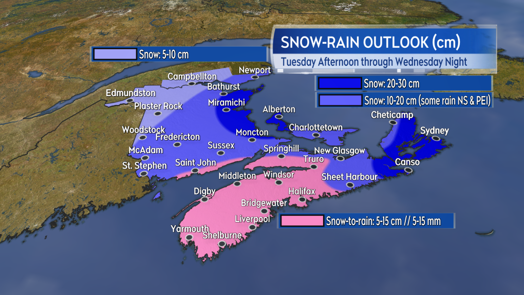
The most snow is expected in a band through New Brunswick, Prince Edward Island, and eastern areas of Nova Scotia. Parts of eastern New Brunswick, western P.E.I., and Cape Breton could see totals of 20 to 30 cm as steadier snow may linger through Wednesday.
The Cape Breton Highlands will likely pick up snow amounts in excess of 30 cm. It’s possible that there may be further accumulating snow in these areas on Thursday.
Snow is forecast lower in the northwestern corner of New Brunswick. Additionally, for much of mainland Nova Scotia and parts of the Bay of Fundy coastline in New Brunswick, a turn to rain may limit snow amounts to five to 15 cm. Those areas could pick up some rain amounts of five to 15 mm and the rain combined with melting snow could lead to some issues with ponding water.
 A large portion of the Maritimes could see snow amounts up to or in excess of 10 cm. The heaviest snow is most likely for eastern parts of the region.
WIND AND SURF
A period of stronger, easterly winds will affect Nova Scotia as well as coastal areas of New Brunswick and Prince Edward Island.
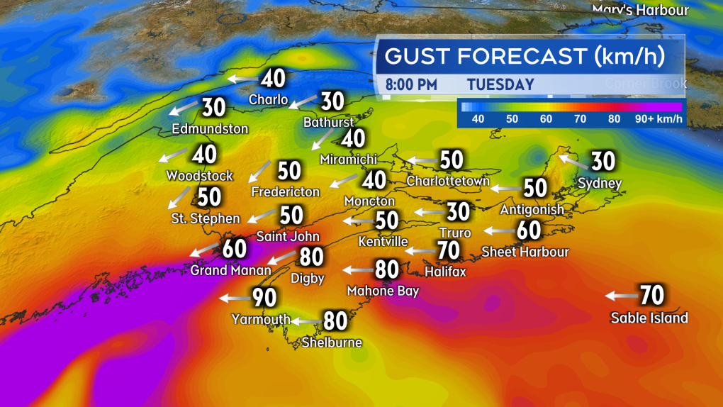
That wind will develop west to east in the region Tuesday afternoon through Tuesday evening. Expect peak gusts of 50 to 70 km/h, except 70 to 90 km/h for areas near the coast.
Stronger gusts up to and in excess of 120 km/h are possible Tuesday night into Wednesday afternoon for northern Inverness County in Cape Breton due to the topography of the Highlands.
The wind on Wednesday will be out of the northeast. Gusts are forecast to range between 30 to 60 km/h. While down slightly from Tuesday, caution should be noted for eastern parts of the Maritimes where the still gusty wind could combine with still steady snow to reduce visibility.
The stronger wind will drive a rough and pounding surf where it is onshore. Higher than normal water levels should be watched for along the Atlantic coastline of Nova Scotia. Extra caution should be taken if near that surf particularly at high tide times Tuesday night into Wednesday.
 A period of stronger east/southeast wind is expected to accompany the initial snow and rain that moves in on Tuesday.
Post a Comment